KARTENWERFT Inland Charts Atlas

 9023-011 KARTENWERFT BinnenKarten Atlas 11 Oberrhein und Neckar
 9023-011 KARTENWERFT BinnenKarten Atlas 11 Oberrhein und Neckar
 9023-011 KARTENWERFT BinnenKarten Atlas 11 Oberrhein und Neckar
 9023-001 KARTENWERFT BinnenKarten Atlas 1 Oder und Haff mit Peene
 9023-002 KARTENWERFT BinnenKarten Atlas 2 Mecklenburgische Seenplatte
 9023-003 KARTENWERFT BinnenKarten Atlas 3 Berlin und Brandenburg
 9023-006 KARTENWERFT BinnenKarten Atlas 6 Mittellandkanal + Mittelweser
 9023-008 KARTENWERFT BinnenKarten Atlas 8 Ems und Friesland
 9023-014 KARTENWERFT BinnenKarten Atlas 9 Niederrhein und Ruhrgebiet
 9023-010 KARTENWERFT BinnenKarten Atlas 10 Mosel und Saar
 9023-012 KARTENWERFT BinnenKarten Atlas 12 Main und Main-Donau-Kanal
 9023-001 KARTENWERFT BinnenKarten Atlas 1 Oder und Haff mit Peene
 9023-002 KARTENWERFT BinnenKarten Atlas 2 Mecklenburgische Seenplatte
 9023-003 KARTENWERFT BinnenKarten Atlas 3 Berlin und Brandenburg
 9023-006 KARTENWERFT BinnenKarten Atlas 6 Mittellandkanal + Mittelweser
 9023-008 KARTENWERFT BinnenKarten Atlas 8 Ems und Friesland
 9023-014 KARTENWERFT BinnenKarten Atlas 9 Niederrhein und Ruhrgebiet
 9023-010 KARTENWERFT BinnenKarten Atlas 10 Mosel und Saar
KARTENWERFT Inland Charts Atlas
from €49.90*
€49.90*
Prices incl. VAT plus shipping costs
Available, delivery time: 1 - 0 Tage
In stock
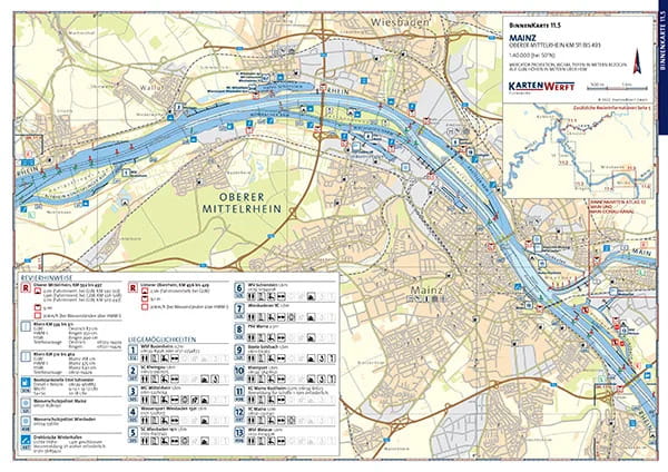
Inland chart atlas in handy, ring-bound A3 format.
Professional cartography in an attractive layout. Easy to use thanks to the clear structure, catchy symbols and north-facing orientation of all charts. Comprehensive textual and pictorial presentation of the respective district sections. The transparent cover protects the maps from splashing water.
The atlas consists of:
- Area overview and planning map for uncomplicated trip planning
- 40 to 56 pages of content
- 26 to 34 map pages
- 26 to 40 inland charts (scale 1:40,000)
- 0 to 2 inland charts (scale 1:80,000)
- 2 to 29 detailed charts (scale 1:27,500 to 1:20,000)
The BinnenKarten Atlas is published in new editions at irregular intervals of two to five years. Please refer to the table for the current year of publication.
The BinnenKarten Digital for the KARTENWERFT NAVGO app (for Android and iOS) can be used indefinitely. They are continuously updated and are up to date when installed.
Thanks to the free RevierService, they remain up to date for one year from initial installation. The RevierService consists of updates to the maps, area information and reports.
Similar products

More articles from this category

